
Clermont County ZIP Coverage
The Clermont County ZIP code directory uses a working inventory of 25 codes from the county AddressPoint service's ZIPCODE domain. That domain describes a point feature for every county address, so it shows which codes occur in the county addressing/GIS environment. It is not an official post-office or neighborhood crosswalk. Verify any complete address with USPS and the county GIS ZIP layer before using a postal label for a place, a record request, or a property search.
| ZIP | Areas Covered | Post Office | Notes |
|---|---|---|---|
| 45102 | Amelia | Not verified in reviewed sources | County GIS address-point-domain code; verify the full parcel. |
| 45103 | Batavia | Not verified in reviewed sources | Includes county-records-campus postal addresses. |
| 45106 | Bethel | Not verified in reviewed sources | County GIS address-point-domain code. |
| 45107 | Blanchester-area overlap | Not verified in reviewed sources | County GIS does not publish the exact delivery crosswalk. |
| 45112 | Chilo | Not verified in reviewed sources | County GIS address-point-domain code. |
| 45118 | Fayetteville-area overlap | Not verified in reviewed sources | Verify the individual address. |
| 45120 | Felicity | Not verified in reviewed sources | County GIS address-point-domain code. |
| 45121 | Georgetown-area overlap | Not verified in reviewed sources | Verify the individual address. |
| 45122 | Goshen | Not verified in reviewed sources | County GIS address-point-domain code. |
| 45130 | Hamersville-area overlap | Not verified in reviewed sources | Not a county-only ZIP. |
| 45140 | Loveland | Not verified in reviewed sources | Multi-jurisdiction postal city; use the parcel for jurisdiction. |
| 45145 | Clermont County address-domain code | Not verified in reviewed sources | Exact postal crosswalk is not published by County GIS text. |
| 45147 | Miamiville | Not verified in reviewed sources | Clermont County/Hamilton-area postal geography; verify parcel. |
| 45150 | Milford / Day Heights area | Not verified in reviewed sources | Multi-jurisdiction postal city. |
| 45153 | Moscow | Not verified in reviewed sources | County GIS address-point-domain code. |
| 45154 | Mount Orab-area overlap | Not verified in reviewed sources | May cross county lines. |
| 45156 | Neville | Not verified in reviewed sources | County GIS address-point-domain code. |
| 45157 | New Richmond | Not verified in reviewed sources | County GIS address-point-domain code. |
| 45158 | Newtonsville | Not verified in reviewed sources | County GIS address-point-domain code. |
| 45160 | Owensville | Not verified in reviewed sources | County GIS address-point-domain code. |
| 45162 | Clermont County address-domain code | Not verified in reviewed sources | Exact postal crosswalk is not published by County GIS text. |
| 45176 | Williamsburg | Not verified in reviewed sources | County GIS address-point-domain code. |
| 45244 | Cincinnati postal label | Not verified in reviewed sources | A postal city is not municipal or county proof. |
| 45245 | Cincinnati postal label | Not verified in reviewed sources | A postal city is not municipal or county proof. |
| 45255 | Cincinnati postal label | Not verified in reviewed sources | A postal city is not municipal or county proof. |
County GIS also supplies a downloadable ClermontZipcodes.zip layer dated March 24, 2025. Treat this ZIP code directory as a working county-serving inventory, not a final postal map. The dataset and AddressPoint domain explain the inventory's local basis, but neither removes the need to validate an edge address. No individual post-office assignment is asserted here because the reviewed county material did not publish one for each code.
Clermont County ZIP Inventory Limits
A ZIP code inventory is a starting list, not a boundary decision. Loveland and Milford are explicitly multi-jurisdiction postal communities, while the Cincinnati-labeled 45244, 45245, and 45255 codes occur in the county AddressPoint domain without proving that an address lies in a city or even within the county. The overlap labels for Blanchester, Fayetteville, Georgetown, Hamersville, and Mount Orab carry the same warning. A complete address must be tested, not inferred from a community name alone.
Clermont County's mixed geography makes the distinction especially important. River communities, historic villages, townships, suburban postal cities, and rural acreage can have several public labels for the same physical location. Keep the postal result separate from the property identity until General Mapping and the Auditor or Recorder record supply the parcel and legal-description context.
Validate Clermont County ZIP Addresses
Finding a place within one delivery area takes an address-validation chain rather than a claimed ZIP-wide resident roll. The most reliable local sequence moves from the postal delivery result to a mapped county address point, then to the property record when an official parcel identity matters. The Auditor distinguishes the situs address, mailing address, and legal description, which may all have different uses. An owner or mailing contact remains different from proof that a person currently lives at a location.
- Submit the complete address to the USPS ZIP Code Lookup and retain the returned delivery result.
- Open Clermont County General Mapping, locate the address point or parcel, and inspect the ZIP layer beside other local layers.
- Use the Clermont County Auditor Real Estate Search for the parcel's situs, owner/tax context, and available legal-description bridge.
- When a land-record identity is required, follow the legal description into Recorder documents rather than treating the postal label as a parcel boundary.
Once the address has been narrowed to a road and parcel, the Clermont County street directory has the separate, modern by-address record chain. A postal result alone does not establish a city limit, county limit, precinct, parcel, or household.
Clermont County ZIP Parcel Research
No reviewed Clermont County portal documents a direct ZIP filter for a countywide property search. The Auditor inspection recorded owner, address, and parcel modes, but not a ZIP field. General Mapping can display the ZIP layer, yet its official guide does not document a ZIP query box. For a postal-area study, browse or select the map layer, or use the downloadable GIS data, then perform individual parcel or Auditor searches. That is slower than promising a filter that was not verified, but it matches the documented tools.
| USPS ZIP Code Lookup | Complete-address validation is the first postal check; it is not a Clermont County jurisdiction or parcel database. |
|---|---|
| General Mapping | Documented searches are address, parcel ID, owner, and roads. ZIP is a display layer; no ZIP query field was verified. |
| Auditor Real Estate Search | Documented modes are owner, address, and parcel. No ZIP portal filter was verified on the inspected screen. |
| ClermontZipcodes.zip | Downloadable local boundary data supports browse or selection work before individual parcel research. |
General Mapping's official guide also recommends using less text after a failed address or road search. A short number or road fragment may find the parcel where a fully formatted delivery address does not. The ZIP code directory therefore directs a researcher from a validated address and map layer to individual parcel work, rather than to an unverified bulk filter. This is a map-search tip, not proof that the resulting address belongs to a particular postal area.
Clermont County ZIP Mismatches
A ZIP code is delivery geography. It does not prove a municipality, county, property line, voting precinct, or legal description. In Clermont County, postal-city labels such as Loveland, Milford, and Cincinnati can overlap more than one jurisdiction. For rural land, a route or postal community may sit alongside a township, parcel number, lot or subdivision description, and a Recorder instrument. The correct record question determines which label controls.
Use the postal result for delivery, General Mapping for local spatial context, and the Auditor or Recorder for parcel/legal-description work. If an older address does not fit a current label, compare the old plat or legal description with Sanborn material and the Recorder's street-name-change, annexation, or centerline-survey records. The research did not identify a published countywide renumbering history, so no year is assumed.
- ZIP vs ZIP+4
- A ZIP identifies a delivery area; ZIP+4 adds a more specific delivery segment but does not create a property boundary.
- PO-box ZIP
- A delivery designation for post-office boxes, not evidence of the box holder's physical location.
- Unique ZIP
- A designation associated with one organization or destination when USPS assigns one; no Clermont County example is claimed here.
- Carrier route
- A delivery-route grouping that helps mail operations and does not substitute for a parcel or jurisdiction layer.
Clermont County ZIP Boundary Layers
Clermont County General Mapping is the local tool for separating labels that might otherwise look alike. Its published data includes parcels, addresses, roads, townships, ZIPs, precincts, and zoning. The viewer searches address, parcel ID, owner, and roads; a selected result is outlined in red, and the layer list and legend make it possible to compare the available boundaries. That spatial check is more dependable than treating a postal-city name as a location decision.
A map selection is still a research step, not a household list. Use the selected parcel to reach its property information, then rely on the governing office for the actual record. Municipal permits, for example, depend on the address's jurisdiction, which can differ from the postal community shown by delivery data.
Note: County GIS layers distinguish overlapping geographies, while the Recorder's legal description identifies the recorded land relationship.
Clermont County ZIP Lookup Limits
The Ohio Department of Rehabilitation and Correction offender search is a state-custody lookup with a ZIP field, not a Clermont County ZIP code directory or a current-address tool. Its inspected form accepts last name, first name, county of commitment, residential county, ZIP, status, next parole board hearing, offender number, and sort control. Residential county and ZIP apply only to specified supervision or at-large statuses and may be a last recorded address. A missing result does not establish local absence or present location.
The Ohio DRC offender search is the source for the state lookup shown below.
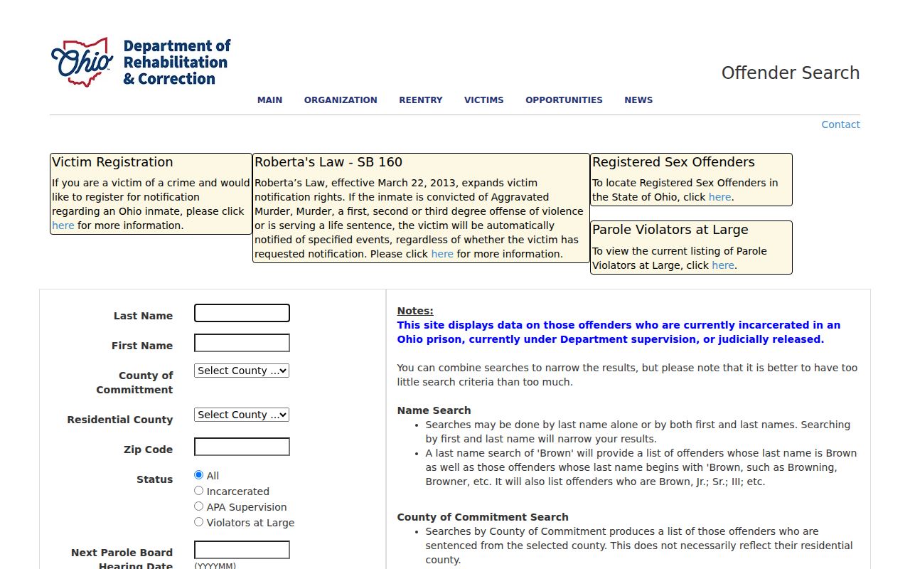
The state form can accept a ZIP as one narrow search field, but its status limits mean it is not a resident directory and cannot prove a person's current address.
Clermont County ZIP Voter Reports
Clermont County's official Candidate Tool provides a Walking List that lets Candidate Tool users query and download registered-voter-address reports as Microsoft Excel. Its documented controls are party, district, precinct, output report format, Generate Report, and Clear Selections; the inspected text did not expose all dropdown values. This is a specific voter-address report tool, not a ZIP search box, a general residents list, or a way to identify ballot choices. Ohio voter history records do not disclose candidate or issue choices.
The official Clermont County Walking List interface is the source for the voter-address report image.
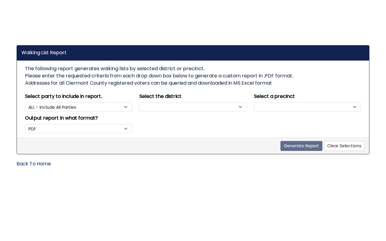
Use a lawful, record-specific purpose and honor Safe at Home, protected-address, and other statutory exclusions. The tool's report does not turn a delivery area into proof of current residence, personal affiliation, or ballot selection.